RAP/RUC Model Extended to 21 Hours

The RAP model (Formely RUC) was increased to 21 hours from 18 hours in run length.  It runs every hour and is completed around 20 minutes past the hour. HH+1:20

The HRRR and RAP models were both upgraded last month.

Details on the Physic changes are as follows:

Technical Implementation Notice 16-26 Amended
National Weather Service Headquarters Washington DC
1047 AM EDT Tue Aug 23 2016

To: Subscribers:
 -NOAA Weather Wire Service
 -Emergency Managers Weather Information Network
 -NOAAPORT
 Other NWS Partners, Users and Employees

From: Tim McClung
 Portfolio Manager
 Office of Science and Technology Integration

Subject: Amended: Upgrade to the Rapid Refresh (RAP) and the
 High-Resolution Rapid Refresh (HRRR) Analysis and
 Forecast System Effective August 23, 2016

Amended to change the date from "future" to August 23 for select
products under the NOAAPORT changes section below.

Effective on or about Tuesday, August 23, 2016, beginning with
the 1200 Coordinated Universal Time (UTC) run, the National
Centers for Environmental Prediction (NCEP) will implement
Version 3 of the Rapid Refresh (RAP) and Version 2 of the High-
Resolution Rapid Refresh (HRRR) systems.

Major Changes:

A major change to the RAP will be an expanded computational
domain which will now include Hawaii. This expansion will
facilitate future NCEP plans for ensemble systems and, in time,
improve the initialization of Short Range Ensemble Forecast
(SREF) members that use the RAP for initial conditions.

Analysis Changes:

Both the RAP and HRRR will use an updated version of the
Gridpoint Statistical Interpolation (GSI) analysis code.
Refinements are made to the GSI to improve the assimilation of
surface observations, soil moisture adjustment, and three-
dimensional cloud and precipitation hydrometeors. In addition,
the HRRR will start using the ensemble/hybrid data assimilation;
it is already used in the RAP, but the weighting of the ensemble-
based component in the RAP will increase from 0.50 to 0.75. In
addition, while the RAP already cycles land-surface states, this
cycling is being introduced into the HRRR. In HRRR Version 1, all
runs are independent.

Other analysis changes include:

-Assimilating radial wind and mesonet data
-Applying PBL-based pseudo-innovations for 2-meter temperatures
(already used for 2-meter dew points)
-Changing the cloud-hydrometeor assimilation to avoid METAR-based
cloud building when satellite data shows clear skies at all times
of day (currently used just in daytime)
-Introducing direct use of 2-meter temperature and dew point
model diagnostics in the GSI.

Specific to the HRRR, the application of radar reflectivity data
in the GSI to direct specification of 3-dimensional hydrometeors
is increased to apply to a broader range of weather conditions,
including warm-season events with reflectivity up to 28 dBZ.

Changes to Model:

- The RAP and HRRR will both begin using WRF version 3.6.1; both
will continue to use the ARW core.
- The MYNN planetary boundary layer scheme is being updated to
include the effects of subgrid-scale clouds. The mixing length
formulation in the boundary layer scheme and thermal roughness in
the surface layer are being changed.
- The 9-level RUC land-surface model is being updated to add a
mosaic approach for fractional snow cover, improve the fluxes
from snow cover, and modify the wilting point for cropland use.
- Major updates are being made to the Thompson microphysics
scheme, including making it aerosol-aware with use of an ice-
friendly and water-friendly aerosol field.
- Shortwave and longwave radiation have been changed to use the
RRTMG (RRTM global) scheme that includes the effects of aerosols
and boundary layer subgrid-scale clouds.
- The WRF-ARW diagnostics for 2-meter temperature and dew point
are being improved.
- The convective scheme in the RAP is changed from the Grell 3-D
scheme to the scale-aware Grell-Freitas scheme. The HRRR, at 3 km
horizontal resolution, explicitly resolves convection and does
not use a convective scheme.

Many of these changes to the data assimilation, land-surface
model, boundary layer scheme, microphysics, radiation, and (in
the RAP only) convective scheme are designed to mitigate the low-
level warm, dry bias in the RAP and HRRR, most notable during
afternoons in the warm season. Significant reduction of these
biases has been evident in extensive testing.

Scheduled System Maintenance – Updated 9/15/16

Update 9/15/16  8:15 AM EDT

The Storage Area Network rebuild is complete as of  this morning.  The HRRR and NAM Surface are back on-line and will be updating as usual.   We appreciate your patience as we went through is period maintenance on the systems.

Update 9/14/16 11:30AM EDT

Work continues rebuilding the Storage Area Network.  Unforeseen problems with the new hardware  have delayed getting the systems back on-line. We hope that the new parts that arrived this morning will resolve this and the network and disk subsystems should be back up later today.

Update: 9/13/16  3:30 AM EDT

Work continues rebuilding the storage array.  Problems were encountered and have delayed getting all the virtual machines back on-line. We do anticipate all the servers to be operational later today.

Update Monday 9/12/16 12:15 PM EDT

A problem was discovered with the NAM. It is being corrected and the 12Z run is being run and should be available around 17:30Z

NAM – NOAAPORT is available. 

Update: Monday 9/12/16  10:00 AM EDT

Work continues on the Storage Area Network.  We expect the HRRR and NAM Surface Products to be off-line for much of the afternoon today.  The GFS-Hi-res may be off-line for a brief period of time as well, however the GFS -NOAAPORT  will remain on-line.

We apologize for these interruptions of service, but due to a bug in the disk controller firmware, which caused a corruption of the data on our SAN. We are having to off load all our data and rebuild our SAN. This is allowing us to also upgrade the SAN to an all SSD SAN which will be much faster.

Thank you for your patience.


On Saturday (9/10/16) afternoon we will be upgrading our high speed storage area network. In doing so, we will be forced to move some running servers off-line for a period of time this weekend. A few of the operational products will likely be impacted for several hours while the hardware is being upgraded.

We expect the following to be off-line for up to 12 hours.

HRRR
NAM Surface Products
We will update the site once all the products are full restored.

If there is a major weather event this weekend, we will postpone the hardware maintenance.

Unusually High Risk of Tornadoes With Hermaine Landfall Across Coastal Georgia & South Carolina Friday

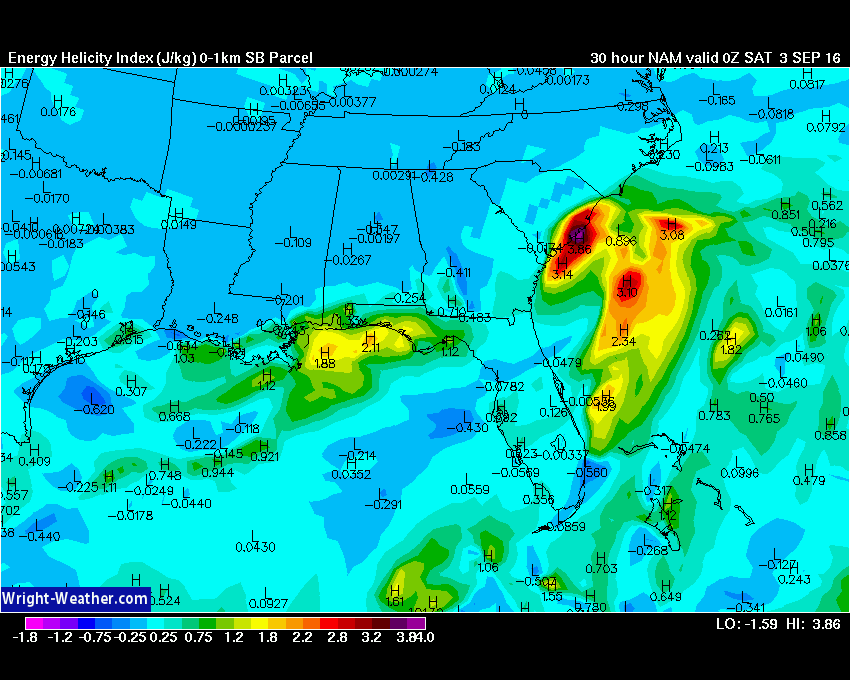
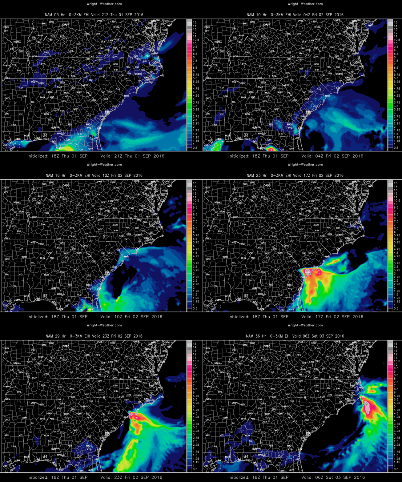
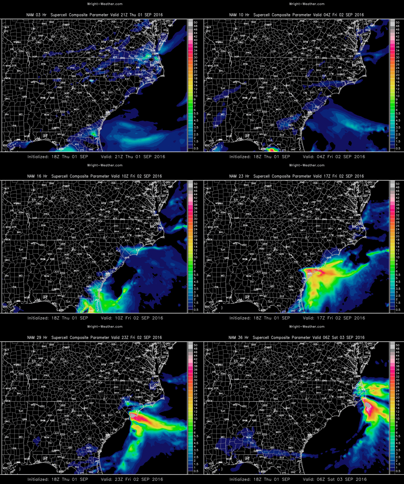
Hurricane Hermaine will make landfall in the Florida Panhandle tonight and then likely track up the coastal plain of Georgia into the Carolina’s on Friday. Seldom seen, with a tropical system, a mix of highly unstable air off the Atlantic ocean interfaced with extreme shear/helicity over Southeastern Georgia and Eastern South Carolina may combine to produce a number of mini-supercells and tornadoes, some that are stronger than what is typical with tropical cyclones. A highly localized outbreak of tornadic supercells across the Coastal Plain of Georgia and South Carolina is possible.

CAPE values from a number of models suggest a plume of instability will be entrained into the tropical cyclone from the Atlantic westward, coincide with the area of maximum low level helicity near the Georgia/South Carolina Coast Friday. This will be highly dependent on the exact track of the center.

In many tornadic episodes with tropical cyclones, CAPE values can be typically be in the 400-800 J/Kg range, rarely seen above 1500 due to clouds and warm temperatures aloft.

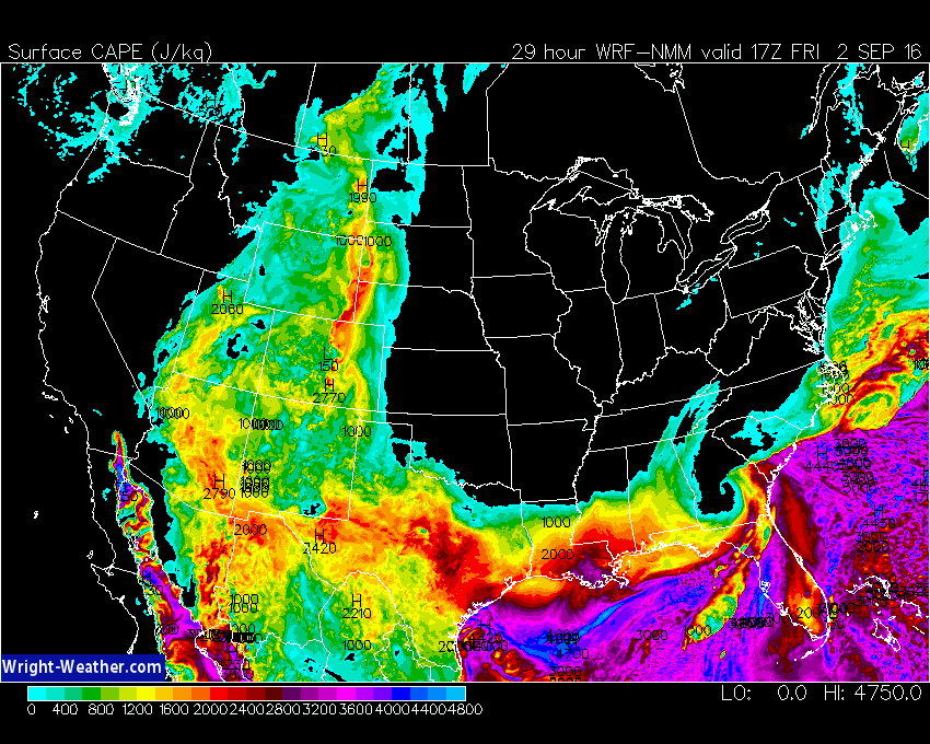
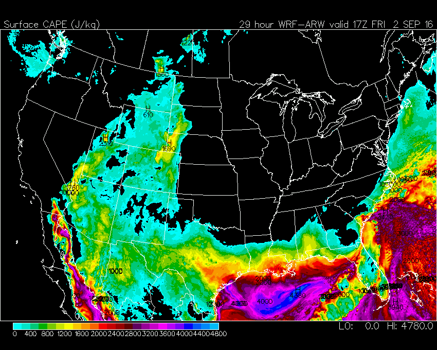
Model simulations from the ECMWF, NAM, NAM-4KM, WRF-NMM, WRF-ARW suggest CAPE values as high as 3000 J/Kg along the South Carolina and Georgia Coastal areas Friday afternoon.

If this materializes, as the models are simulating, an extreme environment is being created across this region where strong to even violent tornadoes could occur.

Forecasters  should pay very close attention to this area, because this is atypical for the type of CAPE/Shear relationship you typically find with a land falling tropical system.

Here are some plots of the 12Z/18Z models for tomorrow highlighting the threat.

Extreme CAPE Values mixed with the TC wind-field potenitally


Very high values of 0-1km EHI for a tropical system

Very high Surface CAPE near the Coastal Plain


Very high Supercell Potential. Typical tropical system do not have high SCP due to low CAPE.

Again Very High Significant Tornado Potential, which is uncommon for land-falling tropical systems.