Upper Level Disturbance Will Bring Heavy Rain to Central/Eastern Carolinas
Flash Flood Threat Exist Tonight & Tomorrow


Upper Level Disturbance Will Bring Heavy Rain to Central/Eastern Carolinas
Flash Flood Threat Exist Tonight & Tomorrow
An apparent brief touch down of a tornado in Central North Carolina yesterday evening was detected by the Raleigh, NC WSR-88D Radar. The RDA was fairly close to the storm with the 0.5 degree beam altitude only around 1390 feet.
While the NWS survey has not yet been completed, it appears this will very likely be an EF0 or EF1 tornado, based on the damage reported, photos and radar data.
The 22:31:59Z volume scan had a small, but defined TVS with gate to gate shear of ~81kts (+57/-24) and a well defined hook echo. It also developed a significant correlation coefficient minimum which was co-located with a reflectivity maximum in the hook where the TVS was also centered.
All of this convinced me, that there was indeed a tornado on the ground and in progress. I quickly put together a “tweet” and sent it out at 22:36Z indicating that we now had a tornado on the ground.
https://twitter.com/Wright_Weather/status/347120537417420802
I also submitted something to the effect, on RAH NWSChat, about a possible debris ball developing on radar.
Shortly there after we started receiving verification of damage and sightings of the tornado.
https://nwschat.weather.gov/lsr/#RAH/201306182218/201306182315/0100
This is another example of how useful the Dual Polarization data can be when looking for Tornado Debris Signatures. Even for locating relatively “weak” tornadoes. Looking at the dual polarization data, it appears the “debris” was lofted to an altitude of around 2600 feet. My thinking is that much of this “debris” is likely tree leaves & foliage from the wooded areas where the tornado crossed, as well as, some other materials.
Click images to enlarge


Next Volume Scan shows "Debris Ball" with reflectivity maxium and correlation coefficient minimum, but velocity couplet weakening indicating tornado dissipating.
Photos of the wall cloud ( Credit: WRAL)

")

Damage to a home in Youngsville, NC

Did the 88D at FFC capture a Tornado ? Dual Pole data may have picked up some debris. Survey may tell later today. Here is a screen shot I took last night while the event was unfolding. The velocity data was not very compelling, but in the previous 3 volume scans there were much better indications of a circulation.
Click images for much larger view


Complicated forecast for the Ohio-Valley into West Virginia and Western Pennsylvania, Wednesday into Thursday Morning. As indicated in last nights discussion, synoptic forcing is very strong and will create favorable conditions for a large area of severe weather as an intense low pressure for this time of year, moves across the Ohio Valley. The primary forecast problems are the convective mode that the storms take once they develop and whether the downstream ambient environment is contaminated by earlier convection that will disrupt the inflow and stabilize the boundary layer. This is exactly what happens with the WRF-NMM and WRF-ARW 4KM models, each a little bit differently. The WRF-4KM NAM CONUS Nest does not, and creates very little convective contamination prior to the main system arriving and develops a very dangerous environment across IL/IN/OH/ Western PA that would support a widespread severe weather event with supercells. While not explicitly, it would likely yield some tornadoes given the intense parameters it is generating.
Below are some animated GIF’s from the WRF-NMM to illustrate the forecast issue of convective contamination of the environment prior to the main forcing/convection related to the surface low. If this AM convection does not develop across WV/VA as indicated, the stable outflow may not be near as strong and may not provide the cool theta-e values and therefore not weaken the main convective system as much or at all when it arrives late Wednesday night.


Even as it is, with some possible convective contamination. The mesocale models are generating some strong indications of a wide spread severe weather event.
Across the Ohio-Valley Wednesday into Wednesday night, the 0-1km helicity and the 0-6km shear will increase as the surface low deepens and the upper level shortwave approaches. Kinematic forcing will favor the formation of supercells and possibly tornadoes over a fairly large area, but the most favorable location will be just south of the stationary front/warm front which will maximize the 0-1km helicity.
Here is just one of the Updraft Helicity products from the various mesoscale models. This is from the WRF-NMM. It’s developing a long lived Supercell from just west of Chicago and tracking it southeastward. Other supercells develop across Indiana and Ohio. This is one of the longest and most intense updraft helicity values I have seen since observing these parameters.


While the threat from widespread damaging wind is certainly high and linear mode convection may very well be the primary mode of convection for the duration of this event. I feel that there very well may be a period of time where there are either discrete supercells or embedded supercells with in a line. Given all the parameters, I believe the tornado risk is quite high along and just south of the stationary front from Central IL through IN into OH. This is a highly conditional forecast, since convective contamination from earlier storms may affect the environment or if the system becomes a large bow-echo or derecho very early in the evolution, then the tornado risk is greatly reduced.
Here is a map outlining the risk area of tornadoes based on all the available guidance through 05Z.

An anomalously strong late spring upper level trough will develop along the Eastern U.S. Coast by Friday. Two shortwaves, one ejecting out of the southern stream over California, will at least partially phase with a second shortwave that drops southward into the Great Lakes on Thursday. These will combine to strengthen a surface low that will traverse from Iowa eastward to the New Jersey Coast.
Wednesday
A two-day event is expected as severe convection will likely generate near the surface low Wednesday afternoon across Illinois and Indiana where the best forcing will exist, however further east across Ohio and West Virginia additional severe storms may develop with the aid of warm air advection and a mid level wind max in the northwest flow, during the afternoon. If discrete convection develops across Ohio/Western West Virginia on Wednesday afternoon there could be supercells and possibly strong tornadoes, given the favorable shear and other parameters. This is well ahead of the main forcing of the the surface low back to the west.
Wednesday Night
Intense convection is expected to develop across Illinois and Indiana and track eastward during the overnight hours. As the surface low deepens, warm air advection will continue to help destabilize the atmosphere near the warm front which is likely to be near Northern Ohio into Western Pennsylvania . A greater risk of significant tornadoes exist along this boundary. Just north of the warm front elevated convection may produce large hail and damaging winds.
Additional storms may develop further southward into Southern Missouri, Kentucky and Tennessee.
Thursday
As the upper level shortwaves begin to phase, per the NAM. The surface low is expected to slow somewhat and should allow for some destabilzation across the eastern portion of Virginia, Maryland, Pennsylvania, New Jersey during the afternoon.
Wind fields will support supercells and possible tornadoes from Central Pennsylvania to New Jersey southward into the Carolinas . The best parameters for significant tornadoes on Thursday will exist near the warm front across Pennsylvania, Maryland, Delaware & into New Jersey.
Below are some of the products used to create the outlook.


")


")
")
")

 NAM Forecast Sounding for Columbus, OH Wednseday Evening.

If convection can initiate and overcome the convective inhibition across eastern Ohio Wednesday afternoon, the environmental conditions are favorable for discrete supercells and tornadoes.
Forecast Sounding for Baltimore, MD for Thursday Afternoon at 2PM EDT
NAM Sounding would support severe storms and possible tornadoes.

With mobile Doppler radar units that have become available in the past 20 years that have extremely high resolution, we have been able to discover tornadic wind speeds in a few of the sampled tornadoes that have approached or in one case exceeded 300 mph. The recent El Reno tornado on May 31st, 2013 was another example of one of these.
Since the force of the wind does not grow linearly, rather it is squared (wind speed^2), these extreme wind speeds over 200 mph can cause unbelievable destruction. Since the kinetic energy is in the same arena as a small nuclear bomb, should one of these ”Super Twisters” hit a densely populated urban environment the destruction would be exponential compared to a lower category tornado. I created a graph to try to visually demonstrate the energy release or damage potential of the 2013 El Reno tornado as compared to just a few other recent tornadoes that have had good NWS storm surveys and tornadoes that had mobile Doppler radar measurements. There is a cluster of Super Tornadoes in the upper right hand portion of the graph that illustrates how much more destruction they can create than an EF3 or EF4 tornado if they encounter buildings, cars or people.
I think it also illustrates that there is a huge range in the EF5 scale. Maybe now that we have entered the era of reliable remote sensing and we know there are tornadoes with wind speeds near or even above 300mph and the energy release is so much greater than a 201 mph EF5 tornado, the idea should be at least entertained about adding an additional(s) EF categorie(s) to account for these rare, but extremely violent tornadoes given the their potential destruction and design limits required to survive them.

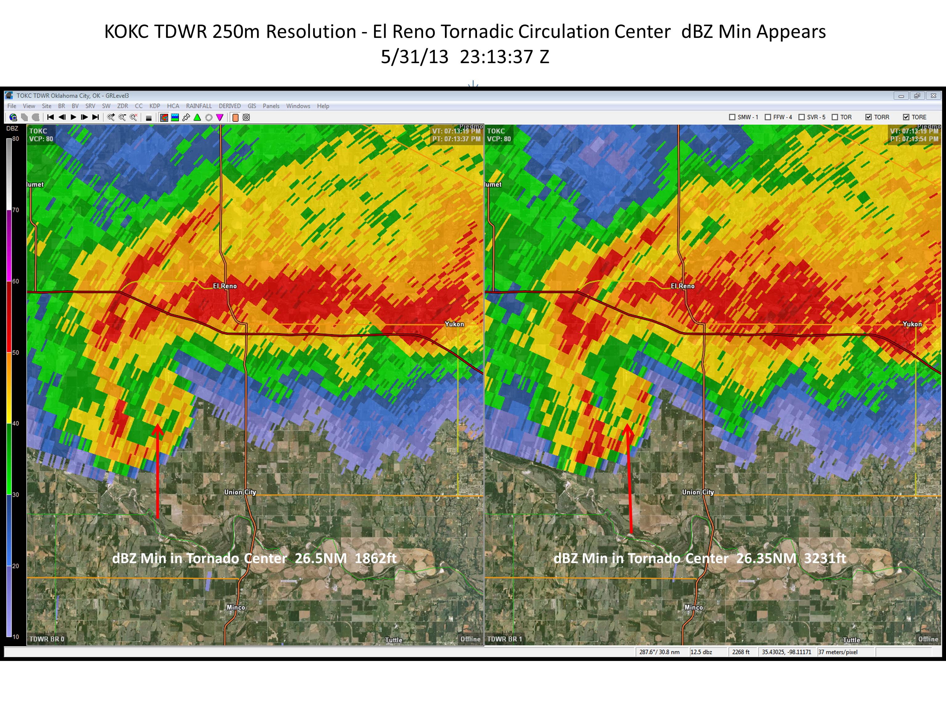
The May 31st EF5 El Reno Tornado that killed several storm researchers was sampled by ground based mobile X-band doppler radar (RaxPol) with very high resolution and found extreme wind speeds of almost 300 mph and rare satellite tornadoes. Other conventional fixed based NWS and FAA radars also captured remarkably high velocities and signatures.
Below is the Terminal Doppler Weather Radar from Oklahoma City (TDWR). A C-Band Radar with a high resolution receiver (250 meter resolution data displayed) and it appears to capture an apparent reflectivity minimum in the center of the tornado at the *exact* same time that the RaxPol indicated the same feature in the tornado. This is quite remarkable considering the distance from the radar is 26 miles. This reflectivity minimum is likely caused by descending air within the tornado and centrifuging of debris and precipitation in this case.

This is the RaxPol image from the exact same time as the TDWR image above.

The National Weather Service WSR-88D in Norman, OK recorded some of the fastest winds I am ever aware of. I am quite sure these winds are legitimate. Below is a screen shot of the tornado at 23:24Z

NWS KTLX Radar indicating maximum winds of 224 mph.
